A satellite-enabled peek at Saudi oil.
Showing posts with label saudi aramco. Show all posts

Friday, June 25, 2010

Crude Confessions: Massive Saudi Spill in 1993?

A mishap during the loading of an oil tanker off Saudi Arabia in 1993 initiated a cascading disaster, resulting in what was the largest offshore oil spill ever, but the oil was mostly recovered by deploying supertankers to vacuum up the spill. This is the story told by a former Saudi Aramco engineer in concert with his efforts to convince BP and the U.S. Coast Guard to consider this approach for cleaning up the recent oil spill in the Gulf of Mexico.


While the possibility of a spill-tested but presently ignored solution to the unfolding environmental mess is very intriguing, I was equally drawn to the fact that, if the story were true, Saudi Aramco had managed to keep this massive spill and its mostly-successful remediation a secret for over sixteen years. Not unexpectedly, Saudi Aramco has denied that this spill took place. Who is telling the truth?


Who cares! Start the movie!


Background: The Oils of War


The Arabian (or Persian) Gulf is not one of the more pristine bodies of water, given that it is the conduit for a good chunk of the world's oil and perforated at its rather shallow bottom with hundreds of wells. But what is currently believed to be the largest spill happened not as a result of an accident, but rather as war strategy. On January 16, 1991, Allied forces began bombing Iraq in preparation for the military reconquest of Kuwait. About 2-3 days later, Iraq began releasing oil from the Kuwait Sea Island terminal into the Arabian (Persian) Gulf. This spill was later augmented by oil from other sources including tankers and refineries. The oil flowed for about 10 days, and although the total amount of oil spilled is not precisely known, and EPA estimate of 6 million barrels makes this the largest oil spill on record, surpassing the 3.5 million barrels Ixtoc Gulf of Mexico spill in 1980.


Given the direction of water flow in the Arabian Gulf, the shores of Saudi Arabia bore the brunt of the spill:


The largest oil spill in the history of the Gulf hit 700 kilometers (435 mi) of Saudi Arabia’s coastline during the 1991 Gulf War. As it drifted south, the oil sank into wet sands and formed layers of tar that poisoned the breeding grounds of fish and crustaceans. Teams from Saudi Aramco worked around the clock to protect vital water-intake channels used for power generation, desalination and injection, and they recovered more than 1.2 million barrels of oil—the largest amount ever collected from a spill—thus sparing hundreds of kilometers of beaches and intertidal areas.


Years later, the environmental effects were still being assessed all over the Gulf. Studies continued for many years, many scientific papers were published, and oil companies developed emergency spill response plans to handle such situations. But according to one report, an even bigger spill happened sometime in 1993, but nobody told anybody who was still fretting over the previous largest spill.


Déjà vu, Oil Over Again


In Esquire Magazine's The Politics Blog, former Shell Oil President John Hofmeister was being interviewed by writer Mark Warren about BP's response to the current crisis when he said this:


JH: The work going on to close the well is taking multiple approaches, and I am aware that BP has sent out a message to all the oil companies asking for help and advice. And I actually sent some people to BP in terms of the spill response cleanup to try to get them aware of a process that has been used in the Arabian Gulf that has not been used in the Gulf of Mexico, and that is to use supertankers, empty supertankers, to suck up the oil off the surface, where they can store the oil, they can treat the water, they can discharge the water and then they can either salvage the oil or destroy it, as the case may be. And I know the mayor of New Orleans and a few other officials are now asking BP about that process as a result of these engineers coming forward from Saudi Aramco.


ES: When did that spill happen, John?


JH: I don't actually know, but it was sometime back, there was a huge, huge spill that never got reported, because they don't have an open press, obviously... But I was told it was a 700-million-gallon spill.


ESQ: That would be the biggest, right?


JH: That would be the biggest the world has ever known. And they used six supertankers to clean up the oil and were very successful. We'd do well to get supertankers in the Gulf.


Hofmeister learned of the Saudi spill during the recent Offshore Technology Conference in Houston in a conversation with Nick Pozzi, who was employed by Saudi Aramco and had first hand knowledge of the cleanup (although not the incident itself). Pozzi and his current business partner, attorney Jon King, have been trying to persuade BP to consider the strategy that seemingly worked on a much larger spill in 1993.


Warren next contacted Pozzi and King and they gave further details of the Saudi spill and cleanup effort.


The primary equipment that was used to remove the crude from the Arabian Gulf was Super Tankers. The Super Tankers were used to store everything, run thru on-shore three-phase separators and sent to on-shore tank farms for additional clean up using centrifuges. The more the oil spreads the more tankers will be needed. Nick would be willing to provide a conceptual non-technical drawing to visualize this process.


Also at the above link is video from the NBC Today show with an interview of Hofmeister.


Oil Port 1993


The thought of six supertankers meandering around slurping up oil like whales feeding on krill invokes wonder. Further details on the incident itself are revealed in a story from AOLNews:


The 1993 Persian Gulf spill, Pozzi says, began when Aramco was loading a tanker and "the umbilical cord got away." Oil started spewing from the pumps. Panicked, a line of tankers waiting to be filled began hightailing away from the flammable spray. Massive ships maneuvered in tight quarters. It was chaos.


Because of a confidentiality agreement with Aramco, Pozzi won't describe exactly what happened next, except to say that "there were [then] other mishaps causing other oil to spill."


"The order of magnitude rose exponentially due to the panic level," he says.


The Politics Blog also had this:


The suck-and-salvage technique was developed in desperation across the Arabian Gulf following a spill of mammoth proportions — 700 million gallons — that has until now gone unreported, as Saudi Arabia is a closed society, and its oil company, Saudi Aramco, remains owned by the House of Saud. But in 1993 and into '94, with four leaking tankers and two gushing wells, the royal family had an environmental disaster nearly sixty-five times the size of Exxon Valdez on its hands, and it desperately needed a solution.


To recap the sequence of events, what we have so far is:


  1. A tanker is loading crude while several (at least three) additional tankers are waiting in line

  2. The "umbilical cord" feeding the tanker is dislodged, spewing crude oil into the water

  3. The tankers begin scrambling to move away from the oil

  4. In the ensuing panic, four tankers end up leaking oil and two wells are somehow uncorked.

  5. 700 million gallons of oil is eventually spilled, with 85% of it collected over six months using supertankers as giant wet/dry vacuums.

  6. Oil is offloaded to onshore gas oil separation plants.


Assuming these details are accurate, the following questions come to mind:


  1. When did the spill happen?

  2. Where could this spill have happened?

  3. Could that much have been spilled?

  4. Where did the tankers used to collect the oil come from?

  5. How would the oil be separated from the water?

  6. Is there any evidence of such a spill?


Alternately, all or part of the story could be fiction. Indeed, after several weeks, Saudi Aramco finally issued a flat denial.


Dhahran, June 22, 2010 -- Saudi Aramco unequivocally refutes allegations reported in several news media and Internet blogs about an alleged "secret" oil spill during 1993 in the Arabian Gulf. The Company states that there is no factual basis to those allegations, and there was no such event or incident as alleged concerning its operations in 1993, 1994, or at any other time. Saudi Aramco confirms that it participated in oil spill cleanup activities and operations in early 1991 during the Gulf Conflict. Under the leadership of Saudi Arabia’s government, the Company, together with various agencies, undertook oil spill cleanup operations lasting for about six months until July 1991. The Company’s response to the 1991 oil spill was carried out with the technologies and best practices available at that time, such as portable skimmers and containment booms.


Although the company utilized a number of work and supply boats, Saudi Aramco wishes to clarify that no supertankers were used during the 1991 spill cleanup operations. The concept of utilizing supertankers to collect large quantities of spilled oil was never pursued. The Company has made reports available to several news media outlets about Saudi Aramco’s involvement in the 1991 spill cleanup. One of the reports was published in Saudi Aramco’s Dimensions Magazine Fall 1996 edition and can be viewed at http://www.saudiaramco.com/irj/go/km/docs/SaudiAramcoPublic/ExternalFile... The Company also confirms that Mr. Nicholas Pozzi is a former employee and worked as a foreman in Saudi Aramco’s East-West Pipeline Department. However, he made no significant contribution to the Company’s spill preparedness or response teams during his employment or at any other time. The claims made about his alleged efforts at a 1993 oil spill response operation are without factual basis.


This seems rather unambiguous. Some might remain skeptical, however, as having to own up to this after so many years would be embarrassing. Would they lie?


The Motivation for Secrecy


Trying to understand the need for Saudi Aramco to keep such an incident secret is probably no easier than understanding their need to keep their oil production data secret. In my articles on various Saudi projects, I have noted several cases where they have clearly been less than forthcoming:


The Oil Drum


Satellite o'er the Desert


Many observers are skeptical about Saudi oil reserves claims as well as the status and oil production level of Ghawar, the world's largest oil field. While there are valid arguments to be made for more transparency, Saudi Aramco can also make valid claims of the need for secrets (for security reasons if nothing else). But an oil spill which could impact other counties coastlines (not to mention its ability to deliver oil to customers) would seem to fall into a different category. The coastline of Saudi Arabia suffered the most from the 1990 spill during the Gulf War:


The Gulf War Oil Spill Twelve Years Later: Consequences of Eco-Terrorism


What Happened To The GULF: Two Years After The World's Greatest Oil-Slick


On one hand, Saudi Aramco has allowed the documentation of many field-related problems in Society of Professional Engineers (SPE) publications. Indeed, Matt Simmons wrote Twilight in the Desert based on an analysis of many such papers. But there is also a curious, almost amateur, approach to the censuring of the papers of name and place data. Nevertheless, information eventually leaks out in some form. A concealment of this magnitude would seem to require a more foolproof approach and motivation.


On the other hand, Saudi Aramco doesn't really admit to any oil spills. From The Tankership Tromedy:


You can see that most of the CTX transfer spills are at the discharge port (activity codes L and d). I would not make much of this. Most load ports are in countries which, whether they are strict or lax, don’t make spills public. The CTX database has no spills at Ras Tanura/Juaymah by far the largest tanker load port in terms of volume. This port loads half-a-dozen big tankers a day. Based on my experience, I’d be surprised if this port averaged less than one spill a week, almost all of them quite small.


Checking Out the Story


Despite the rather emphatic denial by Saudi Aramco, I will look into the possibility of the spill, partly because some of you won't believe them, but also because it's fun. Back to the questions raised earlier:


1) When did the spill happen?


The account says the cleanup occurred from 1993 into 1994, spanning six months, so the spill would have happened in summer 1993.


2) Where could this spill have happened?


(This will take a bit longer to cover)


Most Saudi Arabian crude oil is loaded onto tankers at one of four separate locations: The main oil export terminal at Ras Tanura, the Al Juaymah offshore terminal about 20 miles northwest of Ras Tanura, a similar but smaller offshore terminal in the offshore Zuluf oil field, and the Yanbu terminal on the Red Sea (via pipeline), Below is a map showing the location of Ras Tanura along with those for the major Saudi offshore fields.


Major Saudi Arabian Offshore Oil Fields. Oil export terminals are indicated with reddish dots.

The largest oil exporting terminal in the world is located on the Ras Tanura peninsula and is capable of loading over 5 million barrels of oil per day onto tankers moored on one of two T-shaped terminals (small vessels only) or on one of a cluster of four Sea Islands located offshore in deeper water. The limit for tankers berthed at the Sea Islands is 550,000 dwt (dead-weight tons). Shown below is a satellite image of Ras Tanura seen in Google Earth (this image and those further below copyright Google and Friends).


Ras Tanura Oil Terminal, the world's largest.

Below is a closeup of a tanker being loaded at one of the Sea Islands. Oil is delivered to the islands via underwater pipeline and pumped into the tankers via several Chiksan loading arms, or articulated steel pipes.
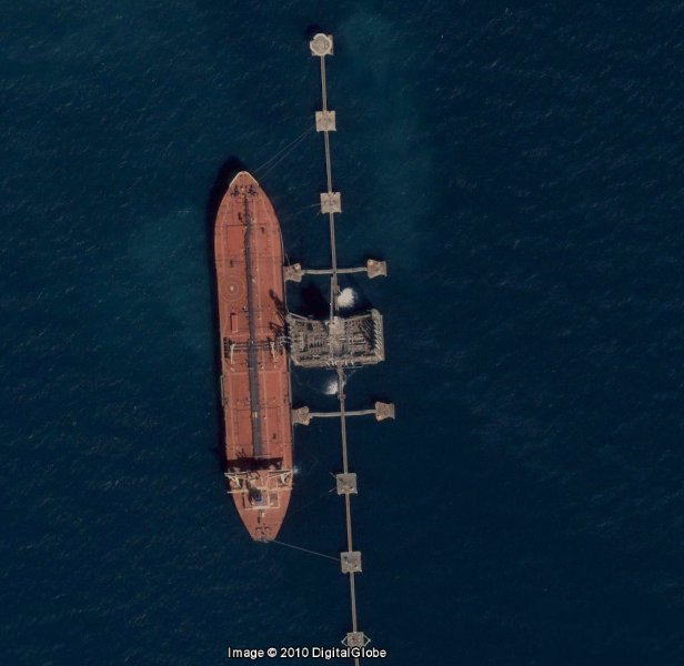


Tanker loading at Ras Tanura Sea Island.

Here is a video of a Chiksan gasoline loading operation gone awry.


The Al Juaymah Offshore Terminal is located to the northwest of Ras Tanura, just east of the Qatif oil field as shown below. The Qatif field lies both on and off shore, with several offshore platforms positioned to drill and maintain offshore wells. Oil is loaded onto tankers from Single Point Moorings (SPMs) anchored in deeper water such that larger ships can be handled (up to 700,000 dwt). It has been in operation since 1974. The Al Juaymah complex also includes a pier from which liquified natural gas (LNG) is loaded onto ships.


Al Juaymah Offshore Oil Terminal (Single Point Moorings)

Oil is similarly delivered from shore in underwater pipeline to a platform, distributed to the SPMs and then transferred to the tanker via large flexible hoses connecting them to the SPM. There are six SPMs at Al Juaymah, which can theoretically output six million barrels per day and has been in operation as early as the 1970s. In a 2005 Google Earth satellite image, I can only find two SPMs, although others might be present in low resolution images.


Two tankers (separated by one mile) loading at Al Juaymah Single Point Moorings in 2005. These tankers are each just over 1000 feet in length.

Shown below is a closeup of the darker tanker from above receiving oil. There are two "hoses" attached to this tanker, whereas there are three attached to the other.


Tanker loading at Al Juaymah Single Point Mooring.

I haven't found anything recent on loading rates, although SPE 4013-MS suggests that each (in the late 1970s) was designed for a flow of at 130,000 barrels per hour but averaged only half that in practice.


The operational principle is that ships can rotate independently around the SPMs, orienting themselves to minimize crosswinds (the two tankers are pointing northwest, which is the direction that the wind normally comes from: down the Saudi shore). The Louisiana Offshore Oil Port (LOOP) in the Gulf of Mexico operates in the same way as Al Juaymah, albeit in reverse (oil is pumped out of the tankers).


Finally, the terminal at the Zuluf field, which reportedly ships oil from the Zuluf and Marjan fields, has only a single SPM. Unfortunately, there are no high resolution images available from Google Earth that might show whether this is still operational, and I haven't found any historical information, either.


3) Could that much have been spilled?


700 million gallons is a lot of oil. There were reportedly three sources:


- Oil from the terminal ("unbilical cord")


- Oil from leaking tanker(s)


- Oil from two "gushing" wells, damaged during the melee


The initial spill was from the supply hoses connected to the tanker being loaded. As seen in the video linked above of a Chiksan loader spewing gasoline, the flow rates can be quite high. This paper discusses tanker loading rates at the Al Juaymah terminal. In case of an accident, a lot of oil can flow in the near term, but there are many ways in which the flow could be stopped, from shutting valves to turning off pumps to just letting the storage tank run out. The amount spilled might be enough to incite immediate panic, but nothing approaching 700 million gallons.


The largest tankers can hold about 2 million barrels, or 84 million gallons. Four such supertankers leaking out all their oil would yield 336 million gallons. Now we're getting somewhere. However, with the exception of the one actually being loaded, the tankers were waiting to be loaded; i.e. they were empty of oil. Beyond that, it would seem that the only way the first tanker could have spilled a ship full of oil is if it was a) filled nearly full, and then b) sank.


This leaves the oil wells. The only realistic scenario would be for a tanker colliding with a platform connected to two or more wells. A problem is identifying platforms that could have actually been involved. There are no wells (or offshore platforms) near Ras Tanura. In contrast, as seen in a map from earlier, there are a few platforms near the Al Jumayah moorings (at least there are now -- Qatif was reworked in 2004, so those platforms might not have been there). However, the nearest of these are for water injectors. The water gets increasingly shallow further into the field (20 feet deep), so it is not clear that tankers would have been able to get there. This leaves only the Zuluf terminal as the only location consistent with the leaking well scenario.


Let's do a simple calculation and assume that of the 700 million gallons (around 17 million barrels) 2 million leaked from the ship(s) and terminal, and that the remaining 15 million barrels flowed out at a constant rate from two wells for six months. This translates to over 40 thousand barrels per day per well. Now, a deepwater GOM well might do this due to the much higher pressure, but the reservoir pressures for offshore Saudi fields do not support this kind of rate, and certainly not for an extended period of time. Early Ghawar wells flowed at perhaps a third to a fourth of that. And the fields that could have been involved, Zuluf and Qatif, were not very productive in 1993; Qatif was essentially dead, and was shut down completely from 1995 until it was reworked (in 2004).


Worse yet, the assumption of a constant flow over six months is not realistic, so it would have to be much higher at first. The reservoir pressures involved (~3000 psi) would not support this flow. It does not seem at all possible to spill as much oil as in the described scenario. The other side of this question is whether they could have collected 85% of it. This is rather doubtful as well, regardless of the amount of oil, because more than 15% would probably have evaporated in the hot summer.


4) Where did the tankers used to collect the oil come from?


Saudi Arabia has (and had) it's own fleet of tankers. Vela International Marine Ltd. is a fully-owned subsidiary of Saudi Aramco based in Dubai. In 1992, Vela had just expanded it's capacity by purchasing four used tankers, giving it eight. In addition, a 1993 merger with the Saudi Arabian Marketing and Refining Company (SAMAREC) gave it access to four medium range product tankers.


5) How would the oil be separated from the water?


In normal operations, a mixture of oil, gas and water flowing from the wells and then through pipelines is separated out in Gas Oil Separation Plants. This is conceptually a simple process, but is rather complicated when undertaken at the rate necessary to handle the volumes coming from the wells. Saudi GOSPs are usually not designed to handle high water cuts. In north Ghawar, new wells were drilled to add new dry oil production to mix with that from existing high-water-cut wells so as to avoid building more GOSP capacity. There was likely limited spare GOSP capacity at that time, as Saudi production was fully ramped up after being throttled back in the late 1980s. Getting oil from the tankers to GOSPs on shore would not have been easy, either.


6) Is there any evidence of such a spill?


It's not enough to say that they could keep the spill a secret because they are a "closed society". The Gulf has a lot of ship traffic, both to the main oil ports as well as near to the Zuluf field. A spill near populated areas would be especially difficult to conceal. The immediate situation was reportedly chaotic, and the oil cleanup operation proceeded for six months and beyond. It is hard to envision how, if this occurred near Ras Tanura, that this could have escaped notice by people not completely within the Saudi Aramco cone of silence. Al Juaymah is far enough offshore that cleanup operations might be more inconspicuous. A big problem would be that dangerous fumes from Qatif wells (very high sulfur content) would have required public safety measures that would not have gone unnoticed.


Summer 1993 was just a few years after the Gulf War Spill. There were many studies undertaken subsequent to that by international research institutions. Water and sediment samples were taken in many locations around the Gulf, including near the possible spill sites during the time in question. There are no reports of any unusual results suggesting a new flow of oil. A study involving tar ball collection on the Qatari coastline showed hints of some increased activity, but the noise is rather high and the time correlation a bit loose:


Tar ball accumulation on the Qatari coast, from [ref]. Note: data arbitrarily offset for clarity.

I did find one internet reference to a possible spill in 1993. At an oil spill workshop and exercise (date unknown), a manager for Bapco, the Bahraini national oil company, said something interesting:


Mr. Al-Ansari addressed the participants in the closing ceremony and stressed the importance of time when responding to oil spills.


He added that when he was Incident Commander in 1993 a large oil spill hit Jeddah Island and if the response then had been five hours sooner, 45% of the overall costs associated with responding to the oil spill would have been saved.


Jeddah is a small island located between Saudi Arabia and Bahrain, looking something like a posh retreat. It remains to be explained what qualifies as a "large oil spill", but it is something. Given Bahrain's close relationship with the rulers of Saudi Arabia, it's likely that no official protest was lodged.


Given the above, it is likely that an oil spill occurred in the Arabian Gulf in 1993. Would the effects from a massive spill be expected to be more pronounced?


In 1980, a blowout at an offshore well in Saudi Aramco's Hasbah field spewed oil for 8 days, for a total of 100,000 barrels. However, the Qatari coastline was affected for months. Hasbah is located southeast of the Zuluf field. Even though it was claimed that 85% of the oil from the purported spill was collected, the first few days (before significant oil collection could have occurred) would have been several times 100,000 barrels, and would have spread over such a wide area that going unnoticed seems unfathomable.


Lastly, we can look at Saudi Aramco's activities subsequent to this. They have been quite active in coordinated spill response drills and workshops. Here is one particular document which discusses many issues:


Saudi Aramco Oil Spill Approach, Prevention, and Readiness


In 1998, Saudi Aramco and the Petroleum Association of Japan (PAJ) conducted a joint exercise to test a coordinated response to a spill in the Arabian Gulf. PAJ had been working since 1991 to safeguard the transport of oil from the Middle East to Asia and had stockpiled oil spill remediation equipment at the Khafji oil field (shared with Kuwait) in 1994. The interesting facet is the description of the scenario given in the paper linked above:


The exercise scenario was developed by PAJ a consultant, Mr. Andrew Crawford of Water born Environmental Limited. The exercise scenario called for an oil spill involving a tank rupture in a Vela vessel during loading operations at Ju’aymah Terminal, which is located about 10 kilometers north of the main terminal at Ras Tanura. In addition, the scenario called for a hose rupture at the loading arm in the terminal, with the combined total amount of oil spilled coming to about 70,000 barrels. The resultant slick would then hit the shoreline and spread offshore near the main Ras Tanura Terminal. Ju’aymah has a major power generation plant at nearby Ghazlan, which would have to be notified to protect its water intake. The Ras Tanura Refinery water intake would also be affected. This amount of oil spillage is higher than the rated capability of Saudi Aramco's oil spill equipment in the Ras Tanura area.


Several questions come to mind here. First, was this really just Mr. Crawford's inspiration? If so, did the Saudi Aramco people present just sit there with poker faces? No mention is made of supertankers as cleanup tools either. But anyway, we have the beginnings for our movie plot. Perhaps Mr. Crawford would get a royalty check. Nick Pozzi...probably not.


Epilogue


Did this massive spill happen?


(cue the closing theme and credits...)

Friday, June 20, 2008

North Ghawar Updated

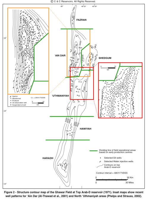
Using the updated Google Earth view (and DigitalGlobe imagery) for Ghawar which includes the Shedgum area, here is an update of the comparison of where older (before 2000) and later wells have been placed.


In the left image, red and blue placemarks indicate locations of oil and water wells respectively. In the right image, green circles denote recent well locations and diamonds indicate drilling rigs.

If the area with remaining oil were an island, it would be time to look for a boat. And given the number of wells involved (400+, probably each with large reservoir contact), this suggests an interesting dynamic in maintaining production at historic levels.

Saturday, March 8, 2008

Khurais Me A River

Khurais. It is the best of fields. It is the worst of fields. It is another chip off the old block, destined to prolong Saudi Arabia's dominance as an oil producer. It is a chink in the armor of the Saudi Oil Miracle, a symbol of a lesser future. Do tell, which is it? Amidst a lot of speculation, there are a few knowns. The Khurais Megaproject is the largest integrated development project in Saudi Aramco history. Slated for completion at the end of 2009, it includes the expansion of oil production in the Khurais, Abu Jifan, and Mazalij fields. These fields lie approximately midway between Riyadh and the Ghawar oil field, and sea water for injection will be piped in from the Arabian Gulf near Dharahan. The completed project is stated to have a capacity of 1.2 million barrels of oil per day. This article will present an early look at the Khurais development using satellite images and a review the scant data available for Khurais in an attempt to assess its prospects in light of much skepticism.

Great Expectations

In "Twilight in the Desert", Matt Simmons questioned whether Khurais could possibly produce that much oil given its spotty prior production record. In contrast, Saudi Aramco lauds Khurais as "the fourth largest oil field in the world" in its Saudi Aramco 2006 Annual Review. Which of these views of Khurais' potential is correct? In contrast to the situation for Ghawar, there is only a limited amount of public data available for Khurais upon which to base an external opinion. Simmons' assessment was based on two Society of Petroleum Engineers (SPE) papers. The first of these, A Production and Operation Review of the Khurais Gas Lift Project (SPE 11447) by Chornoboy and Englehart, addresses efforts in the early 1980s to increase production. The second, a 2002 paper by Al-Afaleg et. al. entitled Successful Integration of Sparsely Distributed Core and Welltest Derived Permeability Data in a Viable Model of a Giant Carbonate Reservoir (SPE 77743-MS), describes an attempt to model previous and potential future production for Khurais using data from well logs and core measurements. For those of us playing along at home, the latter provides some information on the production history and field geology as well as well maps which facilitate a satellite-based investigation of the development status as of December 2007.

Satellite Imagery for Khurais Fields

Shown at right is the geographic setting for the three fields which comprise the Khurais project. The boundary for the Khurais field, corresponding to the oil/water contact, was obtained from well layouts in SPE 77743. The boundaries for the other fields are not explicitely defined in that paper, but there is enough supporting data to enable good approximations.

A fourth field often included as one of the satellites of the Khurais complex, Qirdi, has apparently become the southern tip of Khurais. The total area for the three fields is approximately 1600 sq. km (620 sq. miles), with the Khurais field accounting for 2/3 of the total; this is an area nearly equal to that of the Uthmaniyah section of the Ghawar field.

Google Earth currently (2/2008) displays high resolution DigitalGlobe imagery for the northern half of the Khurais field and nearly all of Abu Jifan dating to mid June 2006. There are also DigitalGlobe preview images of the same vintage images covering the remaining areas. DG previews dating to September 2007 also cover small sections of Khurais, as indicated with blue outlines in figure at right. Finally, two Spot5 preview images provide a blurry but nonetheless informative picture from the end of 2007 in the region of Khurais within the green outline.

Khurais Production History

Why hasn't Khurais been more fully developed? Khurais was discovered in 1957, but oil was not produced to any large extent until the 1970s. Shown below is a composite of oil production and Arab-D reservoir pressure based on data from SPE 77743. Production was via primary depletion. The production increase resulting from the 1980s Gas Lift Project described in SPE 11447 is apparent, as is a later production spurt in the 1990s. The steady drop in reservoir pressure as the oil is extracted is indicative of insufficient support from the aquifer.


Khurais production (red) and Arab-D reservoir pressure (black) 1960-2000


The production values are normalized, but Simmons gives a value for overall field production as 68,000 barrels per day in 1980 and reaching a maximum of 144,000 bpd in 1981 (although the above figure suggests a year or more later). The number of flowing wells in the 1970s is unknown, but at least 50 wells (some of which were new) were contributing to the rate in the early 1980s. A total of 50 wells would yield a flow of somewhat less than 3000 bpd from each.

The pressure behavior obviously does not portend well for long-term production, but it must be remembered that the field was being produced under primary depletion. For example, compare this with the pressure drop observed in the Uthmaniyah area of Ghawar prior to the onset of water injection:


Arab-D reservoir pressure in Uthmaniyah. Data from Benkendorfer et. al., "Integrated Reservoir Modelling of a Major Arabian Carbonate Reservoir" (SPE 29869)

Water injection in Uthmaniyah first began along the flanks in 1966 with gravity assist and then with a pressurized system in 1973. According to one estimate, pre-injection oil production was likely under 400,000 bpd--but still perhaps 5-10 times higher than that from Khurais. Differences in the quality of the reservoir might be the primary cause of this. However, it may also be important that the initial static pressure in Khurais is quite a bit lower than that for the Ghawar fields such that the primary drive mechanism is solution gas rather than aquifer. In any case, it is somewhat misleading to compare oil production from Ghawar under water injection with Khurais under its own steam.

What of the boost in production in the 1980s? This effort to increase production was misread by Simmons as "gas injection", a technique used in 'Ain Dar and Abqaiq in earlier years to maintain reservoir pressure. What was actually employed in Khurais was "gas lift". The distinction between these two is given by Schlumberger as:

gas injection:
  • A reservoir maintenance or secondary recovery method that uses injected gas to supplement the pressure in an oil reservoir or field. In most cases, a field will incorporate a planned distribution of gas-injection wells to maintain reservoir pressure and effect an efficient sweep of recoverable liquids.

gas lift:
  • An artificial-lift method in which gas is injected into the production tubing to reduce the hydrostatic pressure of the fluid column. The resulting reduction in bottomhole pressure allows the reservoir liquids to enter the wellbore at a higher flow rate. The injection gas is typically conveyed down the tubing-casing annulus and enters the production train through a series of gas-lift valves. The gas-lift valve position, operating pressures and gas injection rate are determined by specific well conditions.

SPE 11447 does report problems in some of the 50 wells (in Khurais) where gas lift was employed, but gives an overall positive assessment of the effort. Since it was written while production was ongoing, any reason for stopping production (beyond the decline in the price of oil) is not clear from the paper. Curiously, the Gas Lift project is not mentioned at all in the latter 2002 paper (SPE 77743), even though this would seem to have been critical in accurately modeling oil production during the 1980s and 1990s.

2001 Well Survey (SPE 77743)

By 2001, there were 131 wells placed in the Khurais complex, with 80 of those located in the Khurais field itself. Saudi Aramco initiated a study to determine the best strategy for a full development of the complex. Well logs and measurements on well core plugs were used to determine reservoir stratigraphy, porosity, and permeability. These data were then used to construct a 3D model of the oil-bearing zones.

Shown at right are the 2001 wells identified using Google Earth. Superimposed on the image are contours indicating the top of the Arab-D reservoir, the major oil-bearing structure in Khurais. This formation is an asymmetric anticline with dips averaging 2 degrees and 8.7 degrees on the eastern and western flanks respectively. (Click image for a larger version).

Oil-Bearing Rock

Khurais has three oil-bearing reservoirs: the Arab-D and Hanifa (both API 33 degrees), and Fadhili (API 36 degrees). Most of the wells have been drilled into the Arab-D, with an unknown number into the Hanifa. At least 7 wells have been cored in the Fadhili reservoir, but it has not been produced. SPE 77743 presents a stratigraphic column for the Arab-D reservoir. Unfortunately, absolute thickness of the Arab-D is not revealed. However, this reference:

Anthony E . Adams and Mohamed S . Al-Zahrani, PALAEOBERESELLIDS (DASYCLADACEANS) FROM THE UPPER JURASSIC ARAB-D RESERVOIR, SAUDI ARABIA, PALAEONTOLOGY, VOLUME 43 (2000)

describes a well in south Khurais with an Arab-D layer of 65 meters (213 feet) thick lying at a depth span of 1647-1712 meters (5400'-5617'). Even less has been revealed about the thickness or areal extent of the Hanifa (or Fadhili) reservoirs, although the thickness of the Hanifa in Abqaiq is about 100 m (300 feet) with an areal extent equal to 14% of that for the Arab-D (JoulesBurn, blog post in preparation).

Arab-D Porosity

The stratigraphic column in SPE 77743 includes porosity log measurements. In contrast to Ghawar, where the Arab-D zone 2 has the highest quality, the sweet spot in Khurais is zone 1 (the upper 40%). Zone 2 occupies the middle 20% of the Arab-D, with somewhat lower porosities. The remaining 40% is zone 3, with still lower porosity. The authors excised the scale information, but if one assumes the major divisions correspond to 10% intervals, I have estimated average porosities of 24%, 12%, and 5% for the three zones. Irrespective of the absolute porosity values, this implies that 2/3 of the oil in the Khurais Arab-D lies in zone 1. Below the oil-bearing layers lies 300 feet of the impervious Jubailah formation followed by the Hanifa reservoir. As is the case in Abqaiq, there are fractures through the Jubailah which provide pressure continuity between the Arab-D and Hanifa reservoirs with all sorts of unfortunate consequences.

Permeability

As per SPE 77743, permeability of the Arab-D reservoir in Khurais was measured both from core samples (small scale permeability) and from well tests (large scale). Core permeabilities, presented in cumulative probability distributions, range from a median value of 100 mD in the north to about 5 mD in the south with little variance east to west. However, the effective permeabilities measured in the wells is often much higher (over 10x), particularly along the crest of the anticline, due to fracturing. It was because of this high permeability that proportionally more wells were drilled into the crest. Upon water flood, the risk will be that wells drilled near these fractures could water out early. It is perhaps for this reason that a 3D seismic study was conducted over Khurais and Abu Jifan from 2004-2006 in order to dilineate the fractures.

How Best to Get the Oil Out?

The Khurais oil field seems to have many of the challenges encountered previously by Saudi Aramco before in other fields. Haradh III is one model for how Khurais might be developed, given the lesser quality of the rock relative to the rest of Ghawar as well as the problems with fractures. The challenge of exploiting two reservoirs (Arab-D and Hanifa) has been confronted in Abqaiq, although not (as of yet) successfully. How will this field be developed?

A June 2006 announcement by Abd Allah S. Al-Saif, Aramco senior vice-president exploration and producing, revealed the following:


...the Khurais development plans include drilling 310 horizontal wells and installing facilities for injecting 2 million b/ d of seawater. Included in the 310 wells are 125 water injection wells and 17 observation wells. Al-Saif said the producing wells will have single 1-2-km long laterals and be instrumented with modern real-time, intelligent, downhole completions with "smart" electric submersible pumps. The injection wells will have 1.5-km long laterals, he said.


One surprise is the use of relatively short single-lateral horizontal wells, and another is the use of electric pumps. In contrast, the two most recently (or nearly) completed megaprojects, the Haradh III increment and the Khursaniyah (AFK) expansion, both utilized multi-lateral maximum reservoir contact (MRC) wells for producers. Achieving 1.2 million barrels per day from 168 producers requires an average well productivity of 7142 bpd. By comparison, the single-lateral horizontals in the Haradh II increment reportedly only provide about 3000 bpd of production. Will these be sufficient? Time and future satellite imagery will tell.

Quick, Let's Get Started!

Saudi Aramco met with contractors in March 2006, and in early June announced that Halliburton had been awarded a 3-year contract to drill the wells. Based on satellite images taken less than 2 weeks later, the awardee wasted little time getting things going. Shown at right is the Khurais field with new well development sites indicated by the green placemarks. One drilling rig is also being readied (green diamond in the center of the field). Most of the initial drilling sites are for injectors including a pair on the western flank shown in the closeup below.


Most of the sites are still being prepared, and many earth-moving vehicles are visible as seen below for a group of sites near the northern "bottleneck".


Such a rapid deployment of equipment does not seem possible, even with Halliburton now calling the U.A.E. home. Either they knew well in advance of the contract announcement, or perhaps Saudi Aramco initiated the drilling themselves. It is also noteworthy that this development is occuring nearly simultaneously with the extensive drilling of new wells in Ghawar. Outside the field, the graded areas directly to the east are the likely sites for additional infrastructure being constructed including gas and water facilities. Foster Wheeler was awarded a contract a year prior which included a central processing facility.


September, 2007


Moving ahead about about 15 months, an updated picture is obtained using low-resolution preview DigitalGlobe images as overlays. There as been considerable progress on the central processing facilities and seemingly the construction of an airstrip.


Central Processing facilities east of Khurais in June 2006 (left) and September 2007


Similarly, a region to the southwest also shows a number of new well locations.


Well development in SW Khurais in June 2006 (left) and September 2007


December 2007
As noted earlier, there are two December, 2007 images from the Spot5 instrument which cover nearly all of Khurais. These images are monochrome, and the preview images for these have even less resolution than the DigitalGlobe previews. However, the fresh sites are remarkably distinct even at this resolution as shown at right. The sites visible in 2006 are indicated with green placemarks, and faint yellow circles indicate additional identified sites for the end of 2007 (Again, click image for larger version).

The development plan at this point appears to include injectors spaced 1.5 to 3 km apart with producers located 4 km updip. In addition, there are several clusters of producers where the well spacing is also about 1.5 km, including a large cluster in the south central part of the field. I have tentatively identified about 60 additional sites which, when added to those found in 2006 (about 20), gives perhaps a third to a half of the number allotted for the Khurais field portion of the project. Of course, given the, given the quality of the 2007 imagesused, the uncertainty is large.


Comparison with Haradh III

Although the Khurais project was planned with single instead of multiple laterals, it is still interesting to compare this picture with the layout for the Haradh III increment. In a previous article, the Haradh III well layout was aligned with the satellite imagery, as show at right. The spacing of injectors around the periphery and distance from the injection line to the producers is similar to that observed for Khurais.


Khurais Development vs. Other Drilling
It is clear that development of Khurais has ramped up considerably in 2007 relative to 2006. Of interest is the magnitude of this effort relative to maintaining production from existing fields. Saudi Aramco seemed to provide an answer to this question as reported by Oil Daily Reports:


In December 2006, Saudi Aramco announced its 2007 exploration and drilling budget of almost $4 billion - nearly double the draft budget and full quarter of Aramco’s 2007 capital budget.

...Aramco plans to drill 427 onshore and offshore crude oil development wells in 2007. Approximately 134 wells will be in or near Ghawar, while 85 will be drilled in Khurais, and some 50 drilled in Khursaniya.


This continued drilling of Ghawar in 2007 is comparable to what I found for 2006. If what the satellite imagery above shows is only reflective of 85 wells (plus a few in 2006), 2008 should be a busy year in Khurais.

Abu Jifan and Mazalij

I haven't presented any imagery from these fields, and there has definitely been activity there in the last couple of years. However, the lack of high resolution imagery for Mazalij prevents any clear before and after comparisons, and the (real or apparent) colorations in the imagery for Abu Jifan makes me a little queazy. For example, look at the image below, found on the east side of the field. I can't identify this as anything related to oil production, but there is a similar site not too far away. It looks rather like it's located in Mordor. If you look closely, you can possibly spot orcs and maybe smell the sulfur.


Unknown development in the Abu Jifan oil field


Conclusion: the Good, the Bad, and the Unknown

An early glimpse of the Khurais development has been afforded by satellite imagery using Google Earth. A review of two SPE papers on Khurais suggests more favorable prospects for Khurais reaching its stated production targets than often assumed, although whether this can be done with the planned number of wells remains to be seen (hopefully by satellite). The good: a large field with good porosity in the upper part of the Arab-D reservoir, mixed permeability (at least not overly tight like Shaybah), and light grade crude. The bad: fractures at the crest (the double-edged sword of higher early production but with earlier water encroachment). The unknown: less effective waterflood (as suggested by the need for electric pumps), whither simultaneous (but likely problematic) production from the Hanifa reservoir. One other unknown is whether the fields, once "commissioning activities have been completed"*, will run at "capacity". </sarcasm>

*see the Khursaniyah project delay

Friday, January 25, 2008

Drilling Ghawar in the 21st Century

Ghawar has been churning out oil for over 50 years, and even this massive resource is finite; it has been depleting since day one. As the oil in the reservoir is replaced by injected water from the periphery inward, the outermost wells will begin to produce increasing amounts of water and less oil. To maintain production level, new wells will be drilled in the middle of the field. To what extent has this been going on in Ghawar?

Since wells can be seen on high-resolution satellite images, something can definitely be learned by taking a complete inventory of current wells and comparing with a similar set from several years ago. Since a single satellite view does not have any implicit time information, ideally we would like to have several high-resolution image sets to fully characterize development over a period of time. Some information of this sort is out there -- for a price. However, much can be learned by supplementing a single satellite view with additional information, such as:

  • comparisons with georeferenced published well layouts
  • well appearance (weathering relative to surroundings)
  • well status (in development, drilling, abandoned)
  • is there evidence for the well in earlier (or later) low resolution images


For the 'Ain Dar and Uthmaniyah areas of Ghawar, there are a couple of external sources of well layouts available: an "industry map" discussed by Stuart Staniford in this post at theoildrum.com, and second, several figures in Joe Voelker's Thesis (see Figure 5.6) from Stanford University reprinted from other publications. The precise dates for the well inventories from these figures is not known, although the source publications date from 2000-2002. Also unknown is whether or not they indeed represent complete inventories. For part of the Uthmaniya area, the datasets can be cross checked as there is some overlap between maps. The number of wells present on one map and not the other is relatively small.

For Hawiyah, there is much less available. There is a full Ghawar graphic from a promotional publication by Austin GeoModeling/Recon dating to 2004 (see page 20 in the document) which has well placements. This well inventory likely also dates from around the years 2000-2002, as none of the Haradh II increment wells are shown.

Methodology

The strategy is then to import the map of interest into Google Earth as a raster graphic overlay (ideally with a transparent background) and then align it precisely (georeference) with the visible well locations indicated by placemarks. Wells which have corresponding locations on the map are presumed to have been in place on the date of the map set, and the remaining visible wells are candidates for having been developed more recently. This can often be confirmed by visual inspection as discussed below.

When a well site is prepared for drilling in the Saudi Arabian desert, there is a marked visual change in the color around the wellhead due to less weathering of the newly exposed sand. This difference fades over a number of years. This can be combined with other visual clues, such as the size and shape of the site area. Freshly prepared sites are assumed candidates for drilling within a short time from when the image was taken.

To narrow development dates down further, we can make use of 2003-vintage DigitalGlobe preview images. While the resolution is insufficient to identify wells, one can determine whether a given well present in the high resolution image (2006) was also present in the low-resolution image from a few years earlier (2003).


Results for 'Ain Dar and Uthmaniyah

Wells in 'Ain Dar and Uthmaniyah were geotagged and assigned the following classifications:
  1. "Old" wells present in 2000. Some might have been subsequently reworked.
  2. "Recent" wells developed between 2000 and 2003
  3. "New" wells being developed, ready for drilling, or with active rigs.

The results, shown below, indicate a marked concentration of development toward the middle of the field. Although this is to be expected, the amount of drilling that has occured since 2000 is remarkable.


Oil Wells in North Ghawar: a) before ca. 2000, b) between 2000 and 2003, and c) developed after 2003 including sites prepared for drilling and those undergoing active drilling in summer 2006. Water injectors are not shown.


The results shown in panel c show considerable clustering of development in certain areas, particularly in Uthmaniyah. A closer look at these regions for the motivation behind this trend will be forthcoming.

Results for Hawiyah

Wells in Hawiyah were similarly divided into 3 groups:


  1. Wells present in 2000
  2. Wells added since 2000 but weathered
  3. Fresh (unweathered) wells, prepared sites, and those being drilled


Wells before 2000 (red)
and "aged" wells (green)


New wells and sites


Analysis of well development in Hawiyah is more problematic because only the eastern half is covered in 2006-vintage high resolution. However, similar a similar development pattern is observed on both flanks. New wells in the northeast corner are most probably injectors. Analysis of a 2006 DigitalGlobe preview for the northwest corner suggests about a dozen more wells present by that date, with half of those being new water injectors, although some of the total might be gas wells.

Overall Scope of Ghawar Well Development 2000-2006

In addition to the geographic progression of the drilling in recent years, also notable is the overall quantity of development, as shown in the table below. For example, total of 21 rigs were drilling for oil in May 2006 in these regions. Adding in possible rigs operating in the Shedgum area, this accounts for over a third of the total land rigs drilling for oil in 2006. Moreover, new drilling added 50% more wells in each of the studied in only about 6 years time. Given the high production rate of Saudi wells, with the additional factor that most newer wells are horizontal or MRC wells, a lot of production capacity has been replaced.


Summary of Well Development 2000-2006
Pre-Drill1DrillingFresh> 2003> 2000Older
ANDR22(10)6121495272
UTMH44(40)113329195539
HWYH10(9)325?79159
1Number in parenthesis identified with high probability


[Above table edited 2/20/08. One rig classified as oil was determined to be re-drilling an existing gas well]

One other way to ascertain the extent of drilling over a period of time is to make use of the Saudi Aramco numbering scheme for oil wells. In the Ghawar area, for example, wells are labeled with the subfield prefix (e.g. ANDR for 'Ain Dar) and a sequential number. In 2006, Saudi Aramco engineers contributed the following SPE paper:

IPTC 10395 Optimizing Maximum Reservoir Contact Wells: Application to Saudi Arabian Reservoirs (link)

This paper provides information on 3 MRC wells in north Ghawar, two of them in 'Ain Dar, The first of these, ANDR 524, was drilled sometime in 2004. The other, ANDR 550, was drilled before May 2006. This implies that 27 wells were drilled in 'Ain Dar in two years or less, at rate reasonably consistent with the tabular data above. Note that these are total wells, including gas. As of 2006, there were 5 gas wells in 'Ain Dar, and it is possible that two of these were added during the 2004-2006 time frame.


Two MRC wells in 'Ain Dar. The orange trace
indicates Arab D -6000 ft. contour.

In conclusion, the re-drilling of Ghawar - even excluding the much lauded Haradh III increment -- can justifiably be classified as the largest Saudi Megaproject, at least in terms of wells drilled. And given the observed fact that virtually all of Uthmaniyah and 'Ain Dar have been filled in, there is considerably less room for further development to maintain current production rates.